St. Johns River, FL
Select a photograph to view a photo gallery


Photo Gallery


Photo Gallery
Photo Gallery
|
The river has had almost as many lighthouses as names. The first lighthouse was built in 1830 near the rivers mouth, where the present south jetty is located. Congress provided $10,550 for the tower, which was a large expenditure in what was then the Territory of Florida. To make it worse, the new tower didnt even survive to see Florida attain statehood. By 1835, the encroaching sea had undermined the lighthouse, and it was torn down and replaced by a second lighthouse.
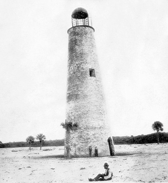
Following a Congressional appropriation of $10,550 on June 30, 1834, the second tower was constructed roughly a mile inland where it was thought to be safe from erosion. This, however, turned out not to be the case. Over time, the shifting river threatened the lighthouse, and sand dunes had nearly buried the dwelling. Congress allocated $10,000 on August 31, 1852 for preserving the site of the lighthouse, and roughly $1,800 of this amount was spent before it was decided to build yet another tower. To fund the construction of the third lighthouse and a companion beacon light to form a range for crossing the rivers bar, Congress provided $15,000 on August 3, 1854 to be used along with the balance of the 1852 appropriation.
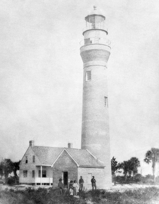
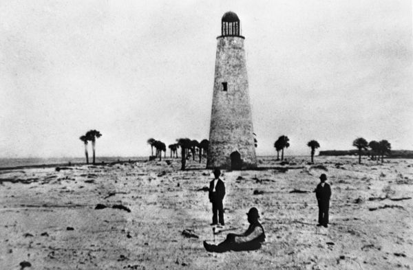
Title for a new site could not be secured until 1857, and work on the tower, which was located over a mile inland, began during the winter of 1857-1858. The new lighthouse was built of brick, stood seventy-four feet tall, and exhibited the light from its fixed, third-order Fresnel lens for the first time on January 1, 1859.
Besides erosion, some early keepers of the lighthouse also proved troublesome. John Warren, who was appointed in 1835, was dismissed in 1838, after it was learned he performed his duty by deputy and had been on a military tour against the Seminole Indians. Stephen Pleasonton, the man responsible for the countrys lighthouses, said the job of a keeper could not be farmed out because a lighthouse could easily become a nuisance instead of a benefit if it was not tended properly. Henry Maxey was hired as the next keeper and was informed of the necessity of residing steadily in the house provided for the keeper, but he had left the place just over a month after his appointment. Matthew H. Phillips was hired as the next keeper, he being recommend as a sober, industrious and moral man, and one in whom the duties of the office may be safely confided.
The 1859 lighthouse had been in operation for just over two years, when the Civil War broke out. Unlike many southern lighthouses, St. Johns River Light operated during a good portion of the war, until a Confederate sympathizer, some say John Daniels, the lights keeper, shot it out in 1864. The lighthouse remained inactive for the remainder of the war, and was finally outfitted with a new third-order Fresnel lens and lantern room and relit on July 4, 1867. John Daniels served as keeper from 1858 to 1870, and for two periods during his tenure, his wife Josephine served as assistant keeper.
|
The motion continued about fifteen seconds, accompanied by a rumbling noise like that made by a side-wheel steamer. Five distinct shocks were felt. The first was moderate, the second and third light, and the fourth and fifth were very light. The first shock commenced with a tremor and ended with a jar. The other shocks seemed like waves coming from the southeast.
In 1890, a brick oil house, measuring nine by eleven feet and capable of holding 450 five-gallon oil cans, was built near the lighthouse, and 1,200 linear feet of new iron-wire fence were placed on the north and west sides of the reservation.
To help keepers mind their lights, the Lighthouse Service installed alarm bells at several stations. If the temperature in the lantern room deviated too much from the normal operating range, a bell was sounded to alert the keeper that the light had gone out or that there was too much fire. In a report dated May 4, 1915, Keeper Amos Buford of St. Johns River Lighthouse wrote:
I was awakened at 3:15 this a.m. by the call of the thermostat bell. When I got up to the light I found the lamp enveloped in flames, caused by the lamp becoming overheated. I extinguished the light and changed the vaporizer and the heating tube, and had the light relit at 3:35 a.m. I had no further trouble for the remainder of the night.Keeper Buford was awakened by the thermostat bell again at 4:45 a.m. on December 22, 1917. This time the light had gone out due to a clogged vaporizer nozzle, and Keeper Buford had to use his substitute light.
In 1887, the Lighthouse Board proposed using an iron superstructure to raise the light at St. Johns River by fifteen feet, so it could be seen above trees on adjacent islands, but this addition was not made when it was found that settlements on the island were steadily clearing away the obstructions. As jetties were being built that would effectively move the rivers entrance farther from the lighthouse, the Lighthouse Board revisited the need for a taller lighthouse to mark the river just a few years later. The Board proposed building a lighthouse atop Mount Cornelia, a hill on the north side of the river with an elevation of sixty-two feet, reasoning that a first-order light with a focal plane of 200 feet in that location would overlap with St. Augustine Lighthouse to the south and Little Cumberland Lighthouse to the north, allowing Amelia Island Lighthouse to be discontinued. After requesting $125,000 for this light annually between 1889 and 1894, the Board brought the matter up again in 1901, but this lofty tower, whose light would have been second only on the Atlantic Coast to that at Navesink, New Jersey, was never built.
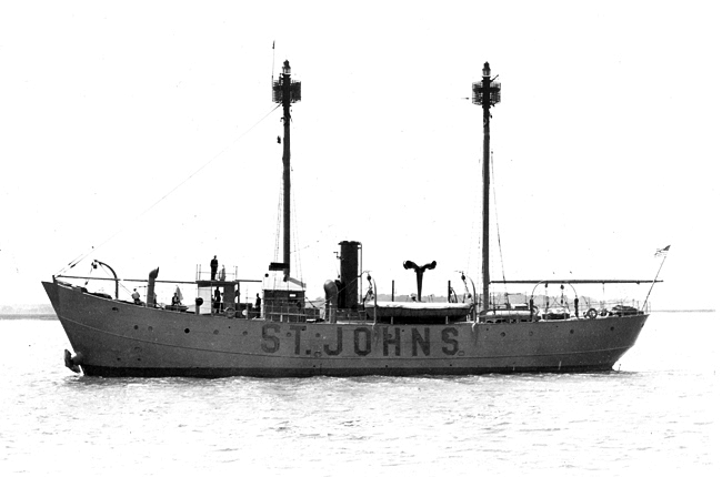
Instead, in 1928, a semiautomatic radiobeacon was established at St. Johns River, and in 1929, the lightship Brunswick, stationed off Brunswick, Georgia, was renamed St. Johns and reassigned to a position roughly seven miles offshore from St. Johns River. The lighthouse continued to operate for a few months after the lightship was placed on station, but when the lighthouse proved redundant, it was discontinued on May 5, 1931.
|
The future of the lighthouse has been the center of much debate. Some leaders envision the lighthouse now guiding tourists, instead of ships, into the area, but with the lighthouse standing on Naval property behind a chain-link fence, providing public access is difficult. A study was commissioned to determine the cost of moving the lighthouse to Mayports river front. The answer: $657,600. Wouldnt it just be a lot easier and cheaper to move the fence?
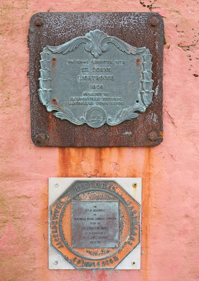
A plaque on the tower records that the City of Jacksonville and Jacksonville Historic Landmarks Commission presented a preservation ward on May 12, 1983 for the rehabilitation of the lighthouse. A second plaque affixed to the lighthouse shows that the lighthouse was placed on the National Register of Historic Places in 1982. The Mayport Lighthouse Association, which was founded in the 1990s, received permission from the Navy in 2000 to use a nearby building as a visitor enter and a museum, but the naval base has been closed to the public since 9/11. There was discussion of relocating the lighthouse to a riverfront location in 2023, but Mayport Waterfront Partnership Director Bill Guillford said that three obstacles would first have to be overcome: receiving permission from the Navy to move the lighthouse, raising $2 million for the project, and finding a way to not disturb burial grounds near the lighthouse.
Keepers:
References
